In the late 1500s, a few decades after the khipu in this recent study was made, an Indigenous chronicler named Guaman Poma de Ayala described how older women used khipu to “keep track of everything” in aqllawasai: places that basically functioned as finishing schools for Inca girls. Teenage girls, chosen by local nobles, were sent away to live in seclusion at the aqllawasai to weave cloth, brew chicha, and prepare food for ritual feasts.
What happened to the girls after aqllawasai graduation was a mixed bag. Some of them were married (or given as concubines) to Inca nobles, others became priestesses, and some ended up as human sacrifices. But some of them actually got to go home again, and they probably took their knowledge of khipu with them.
“I think this is the likely way in which khipu literacy made it into the countryside and the villages,” said Hyland. “These women, who were not necessarily elite, taught it to their children, etc.” That may be where the maker of KH0631 learned their skills: either in an aqllawasai or from a graduate of one (we still don’t know this particular khipu-maker’s gender).
“Science confirming what they already knew”
The finely crafted khipu turning out to be the work of a commoner shows that numeracy was widespread and surprisingly egalitarian in the Inca empire, but it also reveals a centuries-long thread connecting the Inca and their descendants.
Modern people—the descendants of the Inca—still use khipu today in some parts of Peru and Chile. Some scholars (mostly non-Indigenous ones) have argued that these modern khipu weren’t really based on knowledge passed down for centuries but were instead just a clumsy attempt to copy the Inca technology. But if commoners were using khipu in the Inca empire, it makes sense for that knowledge to have been passed down to modern villagers.
“It points to a continuity between Inka and modern khipus,” said Hyland. “In the few modern villages with living khipu traditions, they already believe in this continuity, so it would be the case of science confirming what they already know.”
Some stone tools found near a river on the Indonesian island of Sulawesi suggest that the first hominins had reached the islands by at least 1.04 million years ago. That’s around the same time that the ancestors of the infamously diminutive “Hobbits” may have reached the island of Flores.
Archaeologist Budianto Hakim of Indonesia’s National Research and Innovation Agency and his colleagues were the ones who recently unearthed the tools from a site on Sulawesi. Although a handful of stone flakes from that island don’t tell us who the ancestors of the small species were or how they reached remote islands like Flores and Luzon, the tools are one more piece in the puzzle. And this handful of stone flakes may eventually play a role in helping us understand how other hominin species conquered most of the world long before we came along.
Crossing the ocean a million years ago
Sometimes the deep past leaves the smallest traces. At the Calio site, a sandstone outcrop in what’s now a cornfield outside the village of Ujung in southern Sulawesi, people left behind just a handful of sharp stone flakes roughly a million years ago. There are seven of them, ranging from 22 to 60 millimeters long, and they’re scratched, worn, and chipped from tumbling around at the bottom of a river. But it’s still clear that they were once shaped by skilled human—or at least human-like—hands that used hard stones as hammers to make sharp-edged chert flakes for cutting and scraping.
The oldest of these tools is likely to be between 1.04 and 1.48 million years old. Hakim and his colleagues dated teeth from a wild pig to around 1.26 million years ago. They were part of a jawbone archaeologists unearthed from a layer just above the oldest flake. Throw in some statistical modeling, and you get the range of likely dates for the stone flake buried in the deepest layer of soil.
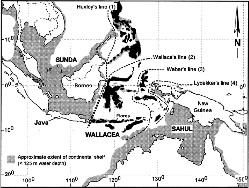
Even the younger end of that estimate would make these tools the oldest evidence yet of hominins (of any species) in the islands of Indonesia and the Philippines. This area, sometimes called Wallacea, lies between the continents of Asia and Australia, separated from both by wide channels of deep ocean.
“But the Calio site has yet to yield any hominin fossils,” said Brumm, “so while we now know there were tool-makers on Sulawesi a million years ago, their identity remains a mystery.” But they may be related to the Hobbits, a short-statured group of hominins who lived hundreds of kilometers away on the island of Flores until around 50,000 years ago.
“The discovery of Early Pleistocene artifacts at Calio suggests that Sulawesi was populated by hominins at around the same time as Flores, if not earlier,” wrote Hakim and his colleagues in their recent paper.
The Flores connection
The islands that now make up Indonesia and the Philippines have been a hominin hotspot for at least a million years. Our species wandered onto the scene sometime between 63,000 and 73,000 years ago, but at least one other hominin species had already been there for at least a million years. We’re just not sure exactly who they were, when they arrived, or how.
“Precisely when hominins first crossed to Sulawesi remains an open question, as does the taxonomic affinity of the colonizing population,” the authors note.
This map shows the islands of Wallacea. The large one just east of Java is Sulawesi. Credit: Darren O’Connell
That’s why the handful of stone tools the team recently unearthed at Calio matter: They’re another piece of that puzzle, albeit a small one. Every slightly older date is one step closer to the first hominin tools, bones, or footprints in these islands, and another pin on the map of who was where and when.
And that map is accumulating quite a lot of pins, representing an ever-increasing number of species. Once the first hominins made it across the Makassar Strait, they found themselves in isolated groups on islands cut off from the mainland—and each other—so the hominin family tree started branching very quickly. On at least two islands, Flores and Luzon, those original hominin settlers eventually gave rise to local species, Homo floresiensis and Homo luzonensis. And University of Wollongong paleoanthropologist Richard Roberts, a co-discoverer of Homo floresiensis, thinks there are probably more isolated island hominin species.
In 2019, when Homoluzonensis was first described, Roberts told Ars, “These new fossils, and the assignation of them to a new species (Homo luzonensis), fulfills one of the predictions Mike Morwood and others (myself included) made when we first reported (15 years ago!) the discovery of Homo floresiensis: that other unknown species of hominins would be found in the islands of Southeast Asia.”
Both Homo floresiensis (the original “Hobbits”) and Homo luzonensis were short, clocking in at just over a meter tall. Their bones and teeth are different enough from each other to set them apart as a unique species, but they have enough in common that they probably share a common ancestor—one they don’t share with us. They’re more like our distant cousins, and the islands of Wallacea may have been home to many other such cousins, if Roberts and his colleagues are correct.
Complicated family history
But who was the common ancestor of all these hominin cousins? That’s where things get complicated (as if they weren’t already). Most paleoanthropologists lean toward Homo erectus, but there’s a chance—along with some tantalizing hints, and no direct evidence—that much more ancient human relatives called Australopithecines may have made the journey a million (or two) years before Homo erectus.
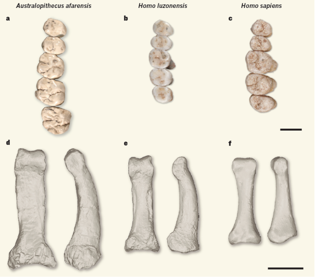
Finger and toe bones from Homo luzonensis are curved, as if they spent as much of their lives climbing trees as walking. That’s more like Australopithecines than any member of our genus Homo. But their teeth are smaller and shaped more like ours. Anthropologists call this mix of features a mosaic, and it can make it tough to figure out how hominin species are related. That’s part of why the question of when the ancestors of the Hobbits arrived on their respective islands is so important.
Compare the teeth and phalanx of Homo luzonensis to those of Homo sapiens (right) and Australopithecus afarensis (left). Credit: Tocheri 2019
We don’t know the answer yet, but we do know that someone was making stone tools on Flores by 1.02 million years ago. Those toolmakers may have been Homo erectus, Australopithecines, or something already recognizable as tiny Homo floresiensis. The Hobbits (or their ancestors) were distinctly “Hobbity” by around 700,000 years ago; fossil teeth and bones from a handful of hominins at a site called Mata Menge make that clear. The Hobbits discovered at Liang Bua Cave on Flores date to somewhere between 50,000 and 100,000 years ago.
Meanwhile, 2,800 kilometers away on the island of Luzon, the oldest stone tools, along with their obvious cut marks left behind on animal bones, date back to 700,000 years ago. That’s as old as the Mata Menge Hobbits on Flores. The oldest Homo luzonensis fossils are between 50,000 and 67,000 years old. It’s entirely possible that older evidence, of the island’s original settlers and of Homo luzonensis, may eventually be found, but until then, we’re left with a lot of blank space and a lot of questions.
And now we know that the oldest traces of hominin presence on Sulawesi is at least 1.04 million years old. But might Sulawesi have its own diminutive hominins?
So are there more Hobbits out there?
“Sulawesi is a wild card—it’s like a mini-continent in itself,” said Brumm. “If hominins were cut off on this huge and ecologically rich island for a million years, would they have undergone the same evolutionary changes as the Flores hobbits? Or would something totally different have happened?”
Reconstruction of Homo floresiensis by Atelier Elisabeth Daynes. Credit: Kinez Riza
A phenomenon called island dwarfism played a role in Homo floresiensis‘ evolution; species that live in relative isolation on small islands tend to evolve into either much larger or much smaller versions of their ancestors (which is why the Hobbits shared their island home with pygmy elephants and giant moas). But how small does an island need to be before island dwarfism kicks in? Sulawesi is about 12 times as large as Flores, for example. So what might the descendants of the Calio toolmakers have looked like by 100,000 years ago?
That’s something that we’ll only know if archaeologists on Sulawesi, like Hakim and his team, find fossil remains of those hominins.
Seafarers or tsunami survivors?
Understanding exactly when hominins first set foot on the island of Sulawesi might eventually help us figure out how they got there. These islands are thousands of kilometers from the Southeast Asian mainland and from each other, so getting there would have meant crossing vast stretches of deep, open ocean.
Archaeologists haven’t found any evidence that anyone who came before our species built boats or rafts, although those watercraft would have been made of materials that tend to decay pretty quickly, so even scraps of ancient wood and rope are extremely rare and lucky finds. But some ancient hominins did have a decent grasp of all the basic skills they’d need for at least a simple raft: woodworking and rope-making.
Another possibility is that hominins living on the coast of mainland Southeast Asia could have been swept out to sea by a tsunami, and some of them could have been lucky enough to survive the misadventure and wash ashore someplace like Sulawesi, Flores, or Luzon (RIP to any others). But for that scenario to work, enough hominins would have had to reach each island to create a lasting population, and it probably had to happen more than once to end up with hominin groups on at least three distant islands.
Either way, it’s no small feat, even for a Hobbit with small feet.
Other July stories: Solving a 150-year-old fossil mystery and the physics of tacking a sailboat.
150-year-old fossil of Palaeocampa anthrax isn’t a sea worm after all. Credit: Christian McCall
It’s a regrettable reality that there is never enough time to cover all the interesting scientific stories we come across each month. In the past, we’ve featured year-end roundups of cool science stories we (almost) missed. This year, we’re experimenting with a monthly collection. July’s list includes the discovery of the tomb of the first Maya king of Caracol in Belize, the fluid dynamics of tacking a sailboat, how to determine how fast blood was traveling when it stained cotton fabric, and how the structure of elephant ears could lead to more efficient indoor temperature control in future building designs, among other fun stories.
Tomb of first king of Caracol found
Credit: Caracol Archeological Project/University of Houston
Archaeologists Arlen and Diane Chase are the foremost experts on the ancient Maya city of Caracol in Belize and are helping to pioneer the use of airborne LiDAR to locate hidden structures in dense jungle, including a web of interconnected roadways and a cremation site in the center of the city’s Northeast Acropolis plaza. They have been painstakingly excavating the site since the mid-1980s. Their latest discovery is the tomb of Te K’ab Chaak, Caracol’s first ruler, who took the throne in 331 CE and founded a dynasty that lasted more than 460 years.
This is the first royal tomb the husband-and-wife team has found in their 40+ years of excavating the Caracol site. Te K’ab Chaak’s tomb (containing his skeleton) was found at the base of a royal family shrine, along with pottery vessels, carved bone artifacts, jadeite jewelry, and a mosaic jadeite death mask. The Chases estimate that the ruler likely stood about 5’7″ tall and was probably quite old when he died, given his lack of teeth. The Chases are in the process of reconstructing the death mask and conducting DNA and stable isotope analysis of the skeleton.
How blood splatters on clothing
Credit: Jimmy Brown/CC BY 2.0
Analyzing blood splatter patterns is a key focus in forensic science, and physicists have been offering their expertise for several years now, including in two 2019 studies on splatter patterns from gunshot wounds. The latest insights gleaned from physics concern the distinct ways in which blood stains cotton fabrics, according to a paper published in Forensic Science International.
Blood is a surprisingly complicated fluid, in part because the red blood cells in human blood can form long chains, giving it the consistency of sludge. And blood starts to coagulate immediately once it leaves the body. Blood is also viscoelastic: not only does it deform slowly when exposed to an external force, but once that force has been removed, it will return to its original configuration. Add in coagulation and the type of surface on which it lands, and correctly interpreting the resulting spatter patterns becomes incredibly difficult.
The co-authors of the July study splashed five different fabric surfaces with pig’s blood at varying velocities, capturing the action with high-speed cameras. They found that when a blood stain has “fingers” spreading out from the center, the more fingers there are, the faster the blood was traveling when it struck the fabric. And the faster the blood was moving, the more “satellite droplets” there will be—tiny stains surrounding the central stain. Finally, it’s much easier to estimate the velocity of blood splatter on plain-woven cotton than on other fabrics like twill. The researchers plan to extend future work to include a wider variety of fabrics, weaves, and yarns.
The uber-rich aren’t like the rest of us in so many ways, including their canny exploitation of highly secretive offshore financial systems to conceal their assets and/or identities. Researchers at Dartmouth have used machine learning to analyze two public databases and identified distinct patterns in the strategies oligarchs and billionaires in 65 different countries employ when squirreling away offshore assets, according to a paper published in the journal PLoS ONE.
One database tracks offshore finance, while the other rates different countries on their “rule of law.” This enabled the team to study key metrics like how much of their assets elites move offshore, how much they diversify, and how much they make use of “blacklisted” offshore centers that are not part of the mainstream financial system. The researchers found three distinct patterns, all tied to where an oligarch comes from.
Billionaires from authoritarian countries are more likely to diversify their hidden assets across many different centers—a “confetti strategy”—perhaps because these are countries likely to exact political retribution. Others, from countries with effective government regulations—or where there is a pronounced lack of civil rights—are more likely to employ a “concealment strategy” that includes more blacklisted jurisdictions, relying more on bearer shares that protect their anonymity. Those elites most concerned about corruption and/or having their assets seized typically employ a hybrid strategy.
The work builds on an earlier 2023 study concluding that issuing sanctions on individual oligarchs in Russia, China, the US, and Hong Kong is less effective than targeting the small, secretive network of financial experts who manage that wealth on behalf of the oligarchs. That’s because sanctioning just one wealth manager effectively takes out several oligarchs at once, per the authors.
The Middle Ages are stereotypically described as the “Dark Ages,” with a culture driven by superstition—including its medical practices. But a perusal of the hundreds of medical manuscripts collected in the online Corpus of Early Medieval Latin Medicine (CEMLM) reveals that in many respects, medical practices were much more sophisticated; some of the remedies are not much different from alternative medicine remedies touted by TikTok influencers today. That certainly doesn’t make them medically sound, but it does suggest we should perhaps not be too hasty in who we choose to call backward and superstitious.
Per Binghamton University historian Meg Leja, medievalists were not “anti-science.” In fact, they were often quite keen on learning from the natural world. And their health practices, however dubious they might appear to us—lizard shampoo, anyone?—were largely based on the best knowledge available at the time. There are detox cleanses and topical ointments, such as crushing the stone of a peach, mixing it with rose oil, and smearing it on one’s forehead to relieve migraine pain. (Rose oil may actually be an effective migraine pain reliever.) The collection is well worth perusing; pair it with the Wellcome-funded Curious Cures in Cambridge Libraries to learn even more about medieval medical recipes.
Physics of tacking a sailboat
Credit: Jonathan King/NYU
Possibly the most challenging basic move for beginner sailors is learning how to tack to sail upwind. Done correctly, the sail will flip around into a mirror image of its previous shape. And in competitive sailboat racing, a bad tack can lose the race. So physicists at the University of Michigan decided to investigate the complex fluid dynamics at play to shed more light on the tricky maneuver, according to a paper published in the journal Physical Review Fluids.
After modeling the maneuver and conducting numerical simulations, the physicists concluded that there are three primary factors that determine a successful tack: the stiffness of the sail, its tension before the wind hits, and the final sail angle in relation to the direction of the wind. Ideally, one wants a less flexible, less curved sail with high tension prior to hitting the wind and to end up with a 20-degree final sail angle. Other findings: It’s harder to flip a slack sail when tacking, and how fast one manages to flip the sail depends on the sail’s mass and the speed and acceleration of the turn.
Maintaining a comfortable indoor temperature constitutes the largest fraction of energy usage for most buildings, with the surfaces of walls, windows, and ceilings contributing to roughly 63 percent of energy loss. Engineers at Drexel University have figured out how to make surfaces that help rather than hamper efforts to maintain indoor temperatures: using so-called phase-change materials that can absorb and release thermal energy as needed as they shift between liquid and solid states. They described the breakthrough in a paper published in the Journal of Building Engineering.
The Drexel group previously developed a self-warming concrete using a paraffin-based material, similar to the stuff used to make candles. The trick this time around, they found, was to create the equivalent of a vascular network within cement-based building materials. They used a printed polymer matrix to create a grid of channels in the surface of concrete and filled those channels with the same paraffin-based material. When temperatures drop, the material turns into a solid and releases heat energy; as temperatures rise, it shifts its phase to a liquid and absorbs heat energy.
The group tested several different configurations and found that the most effective combination of strength and thermal regulation was realized with a diamond-shaped grid, which boasted the most vasculature surface area. This configuration successfully slowed the cooling and heating of its surface to between 1 and 1.2 degrees Celsius per hour, while holding up against stretching and compression tests. The structure is similar to that of jackrabbit and elephant ears, which have extensive vascular networks to help regulate body temperature.
Natural history museums have lots of old specimens in storage, and revisiting those specimens can sometimes lead to new discoveries. That’s what happened to University of Michigan evolutionary biologist Richard J. Knecht as he was poring over a collection at Harvard’s Museum of Comparative Zoology while a grad student there. One of the fossils, originally discovered in 1865, was labeled a millipede. But Knecht immediately recognized it as a type of lobopod, according to a paper published in the journal Communications Biology. It’s the earliest lobopod yet found, and this particular species also marks an evolutionary leap since it’s the first known lobopod to be non-marine.
Lobopods are the evolutionary ancestors to arthropods (insects, spiders, and crustaceans), and their fossils are common along Paleozoic sea beds. Apart from tardigrades and velvet worms, however, they were thought to be confined to oceans. But Palaeocampa anthrax has legs on every trunk, as well as almost 1,000 bristly spines covering its body with orange halos at their tips. Infrared spectroscopy revealed traces of fossilized molecules—likely a chemical that emanated from the spinal tips. Since any chemical defense would just disperse in water, limiting its effectiveness, Knecht concluded that Palaeocampa anthrax was most likely amphibious rather than being solely aquatic.
Jennifer is a senior writer at Ars Technica with a particular focus on where science meets culture, covering everything from physics and related interdisciplinary topics to her favorite films and TV series. Jennifer lives in Baltimore with her spouse, physicist Sean M. Carroll, and their two cats, Ariel and Caliban.
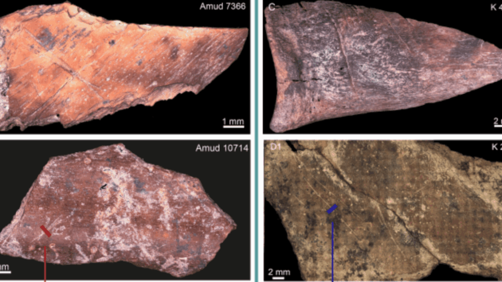
Neanderthals at Kebara had pretty broad tastes in meat. The butchered bones found in the cave were mostly an even mix of small ungulates (largely gazelle) and medium-sized ones (red deer, fallow deer, wild goats, and boar), with just a few larger game animals thrown in. And it looks like the Kebara Neanderthals were “use the whole deer” sorts of hunters because the bones came from all parts of the animals’ bodies.
On the other hand (or hoof), at Amud, archaeologists found that the butchered bones were almost entirely long bone shafts—legs, in other words—from gazelle. Apparently, the Neanderthal hunters at Amud focused more on gazelle than on larger prey like red deer or boar, and they seemingly preferred meat from the legs.
And not too fresh, apparently—the bones at Kebara showed fewer cut marks, and the marks that were there tended to be straighter. Meanwhile, at Amud, the bones were practically cluttered with cut marks, which crisscrossed over each other and were often curved, not straight. According to Jallon and her colleagues, the difference probably wasn’t a skill issue. Instead, it may be a clue that Neanderthals at Amud liked their meat dried, boiled, or even slightly rotten.
That’s based on comparisons to what bones look like when modern hunter-gatherers butcher their game, along with archaeologists’ experiments with stone tool butchery. First, differences in skill between newbie butchers and advanced ones don’t produce the same pattern of cut marks Jallon and her colleagues saw at Amud. But “it has been shown that decaying carcasses tend to be more difficult to process, often resulting in the production of haphazard, deep, and sinuous cut marks,” as Jallon and her colleagues wrote in their recent paper.
So apparently, for reasons unknown to modern archaeologists, the meat on the menu at Amud was, shall we say, a bit less fresh than that at Kebara. Said menu was also considerably less varied. All of that meant that if you were a Neanderthal from Amud and stopped by Kebara for dinner (or vice versa) your meal might seem surprisingly foreign.
That leaves a few possibilities: Denisovans, Homo heidelbergensis (the common ancestor of Neanderthals, Denisovans, and our species), or Homo erectus. All three species could have lived in the area at the time. But nobody at Gantangqing left behind any convenient, readily identifiable bones along with their wooden tools, stone tools, and butchered animal bones (so inconsiderate of them), making it hard to pin down exactly which species these 300,000-year-old hunter-gatherers belonged to.
Homo erectus had been in Asia for more than a million years by the time Gantangqing’s lakeshore was occupied; the oldest Homo erectus fossils in Asia are from Indonesia and date back 1.8 million years. They also stuck around until quite recently. In caves at a site called Zhoukoudian, outside Beijing in eastern China, Homo erectus remains date to sometime between 700,000 and 200,000 years ago (there’s still a lot of debate on exactly how old the site is).
All of that means that Homo erectus’ presence in the region overlaps the age of the wood tools at Gantangqing. And the stone tools found nearby are fairly simple cores and flakes that don’t rule out Homo erectus as their makers. Archaeologists haven’t unearthed evidence of Homo erectus making or using sophisticated wooden tools like this, but for a species that managed to harness fire and cross miles of ocean, it’s not too wild a speculation.
On the other hand, we know that Denisovans were probably in the area, too, or at least not too far away. A recently identified Denisovan skull from Harbin, China, is 146,000 years old but bears a striking resemblance to other hominin skulls from sites all over China, which range from 300,000 to 200,000 years old. And making finely crafted wooden tools fits with everything we know about Denisovan capabilities.
Then there’s Homo heidelbergensis, the direct ancestor of Denisovans. In fact, it’s a little hard to tell where hominins stop being Homo heidelbergensis and start being Denisovans, or even whether the distinction matters. It’s a problem paleoanthropologists refer to as the “muddle in the Middle,” since both species date to the Middle Pleistocene. So if Homo erectus and Denisovans are in the running, so is Homo heidelbergensis, by default.
And unless someone finds a telltale skull nearby or another very similar toolkit at a site with telltale skulls to consult, we may not know for sure.
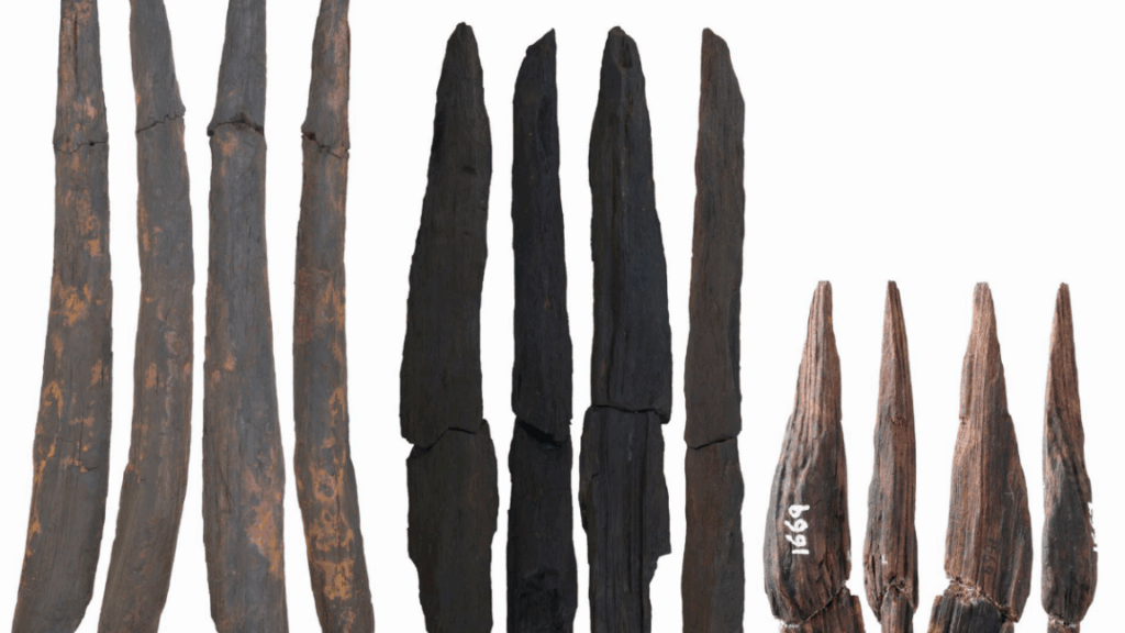
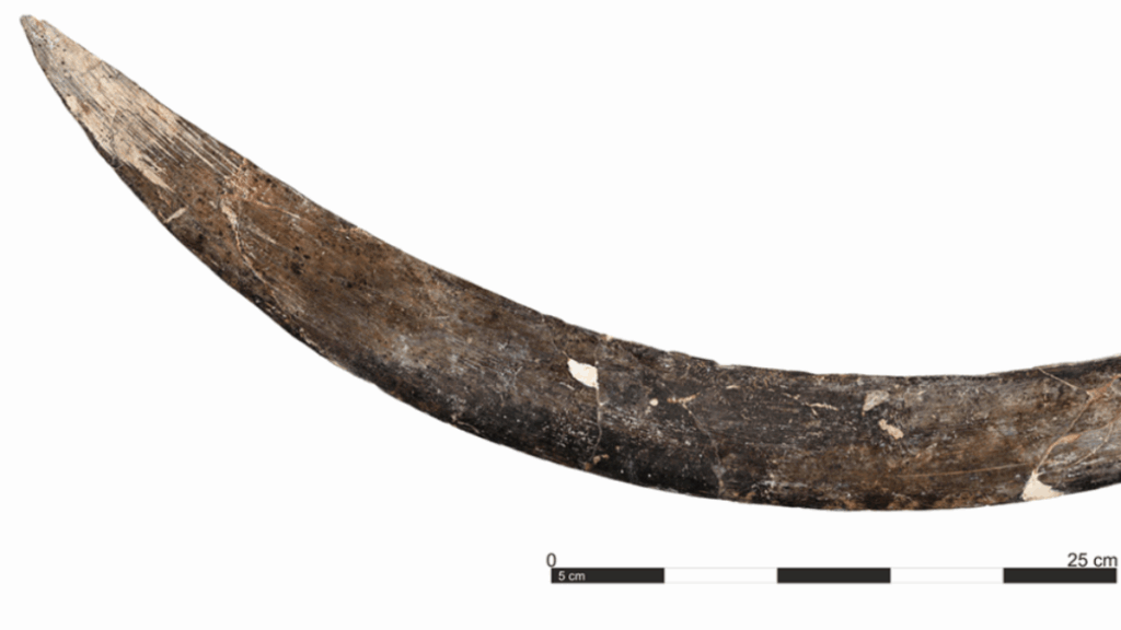
A boomerang carved from a mammoth tusk is one of the oldest in the world, and it may be even older than archaeologists originally thought, according to a recent round of radiocarbon dating.
Archaeologists unearthed the mammoth-tusk boomerang in Poland’s Oblazowa Cave in the 1990s, and they originally dated it to around 18,000 years old, which made it one of the world’s oldest intact boomerangs. But according to recent analysis by University of Bologna researcher Sahra Talamo and her colleagues, the boomerang may have been made around 40,000 years ago. If they’re right, it offers tantalizing clues about how people lived on the harsh tundra of what’s now Poland during the last Ice Age.
A boomerang carved from mammoth tusk
The mammoth-tusk boomerang is about 72 centimeters long, gently curved, and shaped so that one end is slightly more rounded than the other. It still bears scratches and scuffs from the mammoth’s life, along with fine, parallel grooves that mark where some ancient craftsperson shaped and smoothed the boomerang. On the rounded end, a series of diagonal marks would have made the weapon easier to grip. It’s smoothed and worn from frequent handling: the last traces of the life of some Paleolithic hunter.
Based on experiments with a replica, the Polish mammoth boomerang flies smoothly but doesn’t return, similar to certain types of Aboriginal Australian boomerangs. In fact, it looks a lot like a style used by Aboriginal people from Queensland, Australia, but that’s a case of people in different times and places coming up with very similar designs to fit similar needs.
But critically, according to Talamo and her colleagues, the boomerang is about 40,000 years old.
That’s a huge leap from the original radiocarbon date, made in 1996, which was based on a sample of material from the boomerang itself and estimated an age of 18,000 years. But Talamo and her colleagues claim that original date didn’t line up well with the ages of other nearby artifacts from the same layer of the cave floor. That made them suspect that the boomerang sample may have gotten contaminated by modern carbon somewhere along the way, making it look younger. To test the idea, the archaeologists radiocarbon dated samples from 13 animal bones—plus one from a human thumb—unearthed from the same layer of cave floor sediment as the boomerang.
(Left) GPS tracking and modeling of ocean currents toward the end of the experimental voyage. (Right) The team on the water around the time of the left image. Credit: Kaifu et al., 2025/CC-By-ND
At the 30-hour mark, the captain ordered the entire crew to rest, letting the dugout drift freely for a while, which fortunately brought them closer to Yonaguni Island. At hour 40, the island’s silhouette was visible, and over the next five hours, the crew was able to navigate the strong tidal flow along the coast until they reached their landing site: Nama Beach. So the experimental voyage was a success, augmented by the numerical simulations to demonstrate that the boat could make similar voyages from different departure points across both modern and late-Pleistocene oceans.
Granted, it was not possible to recreate Paleolithic conditions perfectly on a modern ocean. The crew first spotted the island because of its artificial lights, although by that time, they were on track navigationally. They were also accompanied by escort ships to ensure the crew’s safety, supplying fresh water twice during the voyage. But the escort ships did not aid with navigation or the dugout captain’s decision-making, and the authors believe that any effects were likely minimal. The biggest difference was the paddlers’ basic modern knowledge of local geography, which helped them develop a navigation plan—an unavoidable anachronism, although the crew did not rely on compasses, GPS, or watches during the voyage.
“Scientists try to reconstruct the processes of past human migrations, but it is often difficult to examine how challenging they really were,” said Kaifu. “One important message from the whole project was that our Paleolithic ancestors were real challengers. Like us today, they had to undertake strategic challenges to advance. For example, the ancient Polynesian people had no maps, but they could travel almost the entire Pacific. There are a variety of signs on the ocean to know the right direction, such as visible land masses, heavenly bodies, swells and winds. We learned parts of such techniques ourselves along the way.”
DOI: “Traversing the Kuroshio: Paleolithic migration across one of the world’s strongest ocean currents,” Science Advances, 2025. 10.1126/sciadv.adv5508 (About DOIs).
DOI: “Palaeolithic seafaring in East Asia: an experimental test of the dugout canoe hypothesis,” Science Advances, 2025. 10.1126/sciadv.adv5507 (About DOIs).
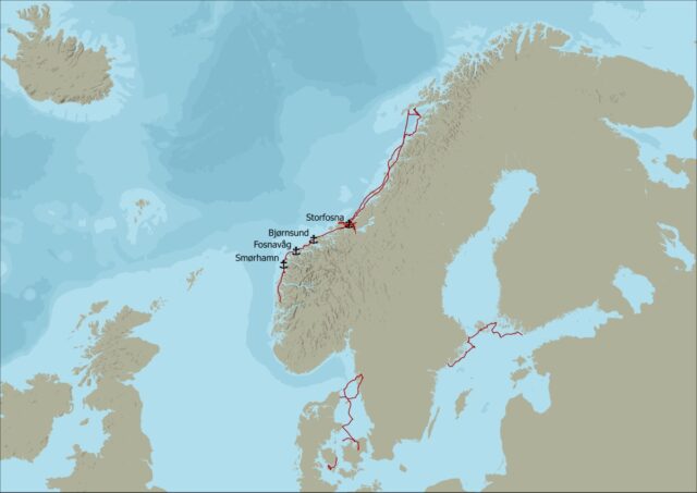
Greer Jarrett has identified four possible small ports, or “havens,” used by Vikings along the Norwegian coast.
Experimental archaeologist Greer Jarrett of Lund University in Sweden has been sailing in the footsteps of Vikings for the last three years.
If you want to learn more about how and where the Vikings sailed, making the journey through the fjords yourself in replica boats is a practical, hands-on approach to achieving that end. Greer Jarrett, an archaeologist at Lund University in Sweden, has spent the last three years doing just that, sailing more than 5,000 kilometers along known Viking trade routes in open, spare-rigged clinker boats similar to those used by the Vikings.
Not only has Jarrett learned a great deal about the boats themselves, he also identified four possible havens along the Norwegian coast, part of what may have been a decentralized network that played a crucial role in trade and travel during that period. And those ports are located farther out to sea than other major ports and hubs known to date, according to a paper he published in the Journal of Archaeological Method and Theory.
It’s just the latest intriguing discovery enabled by the growing field of experimental archaeology, whereby researchers seek to reverse-engineer all manner of ancient technologies. Experimental archaeologists have, for instance, built their own versions of Early Upper Paleolithic adzes, axes, and chisels. The resulting fractures and wear enabled them to develop new criteria for identifying the likely functions of ancient tools. Others have tried to cook like the Neanderthals, concluding that flint flakes were surprisingly effective for butchering birds, and that roasting the birds damages the bones to such an extent that it’s unlikely they would be preserved in the archaeological record.
Kent State University’s Metin Eren has done practical experiments to study, for instance, the trajectories of atlatls attached to spears tipped with replica Clovis points, and how their performance compares to javelins used by Neanderthals. He even fashioned rudimentary blades out of his own frozen feces to test whether they could cut through pig hide, muscle, and tendon—solely to test a famous anthropological legend about an elderly Inuit man in the 1950s who purportedly did the same to kill and skin a dog, using its rib cage as a makeshift sled to venture off into the Arctic. (It did not work, so myth: busted. But it did snag Eren an Ig Nobel prize.)
Taking a hands-on, experimental archaeological approach to studying the Vikings makes sense in light of the dearth of contemporary written sources. “We have a few things written by outsiders, but there’s very, very few accounts written or delivered by people from Scandinavia during that period,” Jarrett told Ars. “We normally rely on indirect forms of evidence, be that genetics or archaeology or linguistics, which show strong, very frequent connections across maritime areas in the North Atlantic. But because traveling by boat is kind of an archaeologically invisible act, you don’t leave any footprints. So we have very little information about the voyages between these points.”
The sailing voyages made by Greer Jarrett during the research project, as well as the four possible Viking harbors he identified. Credit: Greer Jarrett
Garrett and his crew used four or five different replica boats for their test voyages. Most were built by volunteers, enthusiasts, or students Jarrett had met during his considerable time in the field. They then sailed along the west coast of the Scandinavian Peninsula, a core area of Viking seafaring.
“These are reconstructions of traditional Norwegian boats from the 1800s and early 1900s,” said Jarrett. “My idea was, because of this really long-term continuity in traditional boat building practices, especially in Norway, it might be possible to use these later boats which have lots of similarities to try and work out the potentials of where people might have gotten out. It’s the idea of suggesting potentials based on practical experience to try and join those dots between the different evidence we have across the Viking world.”
That decision has led to some criticism from colleagues because of the enormous gap in time, but Jarrett defends his choice. “The Viking Age ends in the 11th century, and we’re talking about boats from 800 years later,” he said. “But the construction techniques and the way they are rigged and their general performance characteristics are similar enough. Because this is a project about voyages and not a project about boat building, it seemed like a defensible analogy.”
Seeking safe harbor
“On the long-range voyages, we worked in watches of four hours on and four hours off, and that is just about long enough to get some sleep on your off watch, but also just about short enough that you don’t get really, really, really cold, which is obviously a risk,” said Jarrett. “It was manageable, but we looked like penguins. I mean, we’re wearing six layers of wool at any time and sleeping all stacked together for warmth. But other times it’s really nice. The spring and the autumn in Scandinavia, there’s much more likelihood of high-pressure cycles, which means that it’s clearer and sunnier than in the summer itself.”
Nonetheless, there were some rough moments, such as when the mast spar holding up the mainsail snapped, forcing the crew to improvise and lash two oars together to hold the sail so they could continue their journey. It took several days to repair the boat so it could sail again. There was no safety boat following along in case the crew got into trouble, and no engine, although they did have a life raft, which the crew has yet to use.
Based on his sailing trials, Jarrett believes that the Vikings had no need for navigational tools like maps, a compass, or a sextant, relying instead on what he calls “mental maps”—or a “maritime cultural mindscape”—based on sailors’ memories and experiences passed down orally through generations. Those maps might also be informed by the myths linked to well-known coastal landmarks, such as skerries, small islets, or reefs.
“People had been moving by boat along the west coast of Scandinavia for a really, really, really long time, probably since the late Neolithic, if not earlier—thousands of years before the Viking age,” said Jarrett. “There are big trading networks in place beforehand, and that is reflected in the names, place names along the west coast. My primary argument is if you spend 3,000 years traveling up and down a coastline in which you can use the coast at all times for navigation, then it’s unnecessary to develop instrumentation.”
“Instruments are used when you are in a place out in the open sea that you don’t know,” Jarrett continued. “We definitely know they didn’t have compasses because those don’t arrive from China until the 1200s. There are these ideas about sunstones and sundials, or little sun compasses, which are entirely possible. But there’s no legitimate proof of either of them archaeologically yet. I may well be proved wrong if we find them at some point, but I don’t think they’re necessary for this at all.”
Based on the sailing trials, archaeological and documentary evidence of Viking Age maritime centers, and digital reconstructions of past sea levels. Jarrett was able develop a useful set of criteria for evaluating potential havens. For instance, the site should be reachable in low visibility, with land or sea marks that sailors could use as bearings; large enough to accommodate multiple vessels of at least the size of a fyring (which can house a crew of four to 10 people); provide good protection from sea swell and storm surges; and have access to fresh water, among other criteria. Four sites scored sufficiently high by those criteria to qualify as possible Viking havens.
The four sites are Smørhamn, located at the confluence of Oldersund and the Frøysjø, where an inn and trading post are known to have existed since at least the late 17th century; the archipelago of Sørøyane between Stad and Ålesund, near where the sea battle of Hjörungavágr was fought circa 986 CE; Bjørnsund, a number of small islands off the southwestern tip of Hustadvika; and the island of Storfosna, which appears on 16th and 17th century charts.
“I’m not saying, ‘This is where they went,'” said Jarrett. “I’m saying that, with these kinds of boats under these conditions, it would be possible to go to these places. And it’s much more difficult—not impossible, but much more difficult—to go to these other places or to sail in these other conditions.”
Pining for the fjords
The next step is for Jarrett and other archaeologists to hunt for evidence in support of his hypothesis. “Most of these sites have never been excavated,” said Jarrett. “There’s been a long assumption that these are landing places with the idea that you are dragging your boat ashore. I’m very opposed to that idea because these are two-and-a-half-ton boats, let alone the cargo. Unless you have a team of oxen and 20 people at your command, there is no way you’re getting them on the beach. I’m very convinced that these places have jetties and mooring posts likely preserved underwater. All of that organic material survives much better underwater than it does on land. So I think that’s very possible.”
They might also find smaller items suggestive of a thriving harbor community. “Whenever you go into land, you’ve got something that’s broken, so you need to do repairs,” said Jarrett. “So things like clink nails or piles of balustones or signs of smithing—the typical kind of things you’d use for repairing your ship, I think are possible to find.” Jarrett’s methodology might also prove useful for studying other seafaring communities.
The practical experience of sailing the same seas as the Vikings naturally led to some surprising insights. “You are able to ask very different questions the minute you walk away from your desk and get on a boat,” said Jarrett. “I think it’s essential to do that because you think in new ways. In terms of the results themselves, the boats are extremely seaworthy crafts. When you get in them for the first time, you don’t think that, because they’re very, very light. They feel very flimsy, and they’re very low in the water compared to a modern sailing boat. So you feel really in touch with the wave, which is kind of scary. But because they’re so flexible and because of the way they’re rigged, they’re actually really stable, even in big waves.”
“We kept going out thinking, ‘Oh, this is maybe the limit of what this boat can tolerate,’ and then it would be fine, and we’d be, ‘Okay, let’s go a little bit in slightly bigger waves with slightly stronger wind,'” Jarrett continued. “So I think our comfort zones definitely visibly expanded during that period. And I had the chance to work with the same crews over three years. By the end of those three years, we were doing stuff that we would never have been able to do at the beginning.”
Another big difference from modern boats, Jarrett discovered, is that one cannot sail a traditional Viking craft alone. “It has to be a collaborative effort because of how you need a person at the front and the back of the boat basically at all times,” he said. “So developing the crew together and gaining not only skills, but also trust between us meant that we could do things in 2024 that seemed completely insane just a couple of years earlier. I cannot imagine what that is like if you have an entire lifetime of Viking sailors working together for 30 years. It must be an incredible way of creating social bonds.”
Jennifer is a senior writer at Ars Technica with a particular focus on where science meets culture, covering everything from physics and related interdisciplinary topics to her favorite films and TV series. Jennifer lives in Baltimore with her spouse, physicist Sean M. Carroll, and their two cats, Ariel and Caliban.
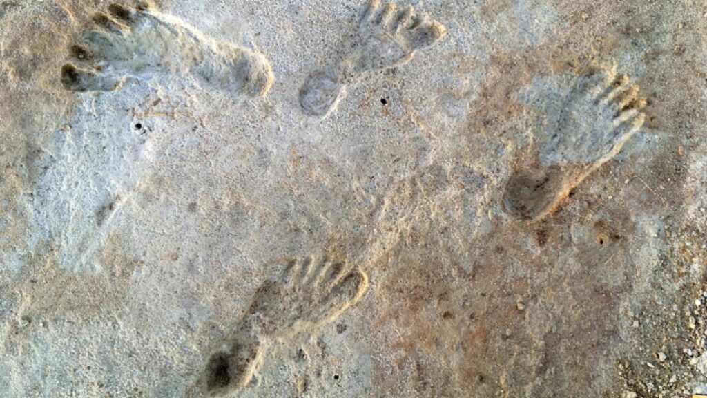
Some of the sediment layers contained the remains of ancient grass seeds mixed with the sediment. Bennett and his colleagues radiocarbon-dated seeds from the layer just below the oldest footprints and the layer just above the most recent ones. According to those 2021 results, the oldest footprints were made sometime after 23,000 years ago; the most recent ones were made sometime before 21,000 years ago.
At that time, the northern half of the continent was several kilometers below massive sheets of ice. The existence of 23,000-year-old footprints could only mean that people were already living in what’s now New Mexico before the ice sheets sealed off the southern half of the continent from the rest of the world for the next few thousand years.
Ancient human footprints found in situ at White Sands National Park in New Mexico. Credit: Jeffrey S. Pigati et al., 2023
Other researchers were skeptical of those results, pointing out that the aquatic plants (Ruppia cirrhosa) analyzed were prone to absorbing the ancient carbon in groundwater, which could have skewed the findings and made the footprints seem older than they actually were. And the pollen samples weren’t taken from the same sediment layers as the footprints.
So the same team followed up by radiocarbon-dating pollen sampled from the same layers as some of the footprints—those that weren’t too thin for sampling. This pollen came from pine, spruce, and fir trees, i.e., terrestrial plants, thereby addressing the issue of groundwater carbon seeping into samples. They also analyzed quartz grains taken from clay just above the lowest layer of footprints using a different method, optically stimulated luminescence dating. They published those findings in 2023, which agreed with their earlier estimate.
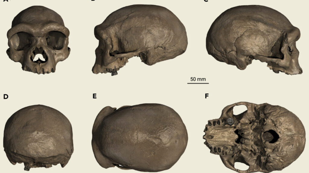
After years of mystery, we now know what at least one Denisovan looked like.
A 146,000-year-old skull from Harbin, China, belongs to a Denisovan, according to a recent study of proteins preserved inside the ancient bone. The paleoanthropologists who studied the Harbin skull in 2021 declared it a new (to us) species, Homo longi. But the Harbin skull still contains enough of its original proteins to tell a different story: A few of them matched specific proteins from Denisovan bones and teeth, as encoded in Denisovan DNA.
So Homo longi was a Denisovan all along, and thanks to the remarkably well-preserved skull, we finally know what the enigmatic Denisovans actually looked like.
Credit: Ni et al. 2021
The Harbin skull (left) and the Dali skull (right).
Unmasking Dragon Man
Paleoanthropologist Qiang Ji, of the Chinese Academy of Sciences, and colleagues tried to sequence ancient DNA from several samples of the Harbin skull’s bone and its one remaining tooth, but they had no luck. Proteins tend to be hardier molecules than DNA, though, and in samples from the skull’s temporal bone (the ones on the sides of the head, just behind the cheekbones), the researchers struck pay dirt.
They found fragments of a total of 95 proteins. Four of these had variations that were distinct to the Denisovan lineage, and the Harbin skull matched Denisovans on three of them. That’s enough to confidently say that the Harbin skull had belonged to a Denisovan. So for the past few years, we’ve had images of an almost uncannily well-preserved Denisovan skull—which is a pretty big deal, especially when you consider its complicated history.
While the world is now aware of it, until 2021, only one person had known what the skull looked like since its discovery in the 1930s. It was unearthed in Harbin, in northeast China, during the Japanese occupation of the area. Not wanting it to be seized by the occupying government, the person who found the skull immediately hid it, and he kept it hidden for most of the rest of his life.
He eventually turned it over to scientists in 2018, who published their analysis in 2021. That analysis placed the Harbin skull, along with a number of other fossils from China, in a distinct lineage within our genus, Homo, making them our species’ closest fossil relatives. They called this alleged new species Homo longi, or “Dragon Man.”
The decision to classify Homo longi as a new species was largely due to the skull’s unique combination of features (which we’ll discuss below). But it was a controversial decision, partly because paleoanthropologists don’t entirely agree about whether we should even call Neanderthals a distinct species. If the line between Neanderthals and our species is that blurry, many in the field have questioned whether Homo longi could be considered a distinct species, when it’s even closer to us than the Neanderthals.
Meanwhile, the 2021 paper also left room for debate on whether the skull might actually have belonged to a Denisovan rather than a distinct new species. Its authors acknowledge that one of the fossils they label as Homo longi had already been identified as a Denisovan based on its protein sequences. They also point out that the Harbin skull has rather large molars, which seem to be a common feature in Denisovans.
The paper’s authors argued that their Homo longi should be a separate branch of the hominin lineage, more closely related to us than to Denisovans or Neanderthals. But if the Harbin skull looked so much like Denisovan fossils and so little like fossils from our species, the alleged relationship begins to look pretty dubious. In the end, the 2021 paper’s authors dodged the issue by saying that “new genetic material will test the relationship of these populations to each other and to the Denisovans.”
Which turned out to be exactly what happened.
A ghost lineage comes to life
Denisovans are the ghost in our family tree. For scientists, a “ghost lineage” is one that’s known mostly from genetic evidence, not fossils; like a ghost, it has a presence we can sense but no physical form we can touch. With the extremely well-preserved Harbin skull identified as a Denisovan, though, we’re finally able to look our “ghost” cousins in the face.
Paleogeneticists have recovered Denisovan DNA from tiny fragments of bone and teeth, and even from the soil of a cave floor. Genomics researchers have found segments of Denisovan DNA woven into the genomes of some modern humans, revealing just how close our two species once were. But the handful of Denisovan fossils paleoanthropologists have unearthed are mostly small fragments—a finger bone here, a tooth there, a jawbone someplace else—that don’t reveal much about how Denisovans lived or what they looked like.
We know they existed and that they were something slightly different from Homo sapiens or Neanderthals. We even know when and where they lived and a surprising amount about their genetics, and we have some very strong hints about how they interacted with our species and with Neanderthals. But we didn’t really know what they looked like, and we couldn’t hope to identify their fossils without turning to DNA or protein sequences.
Until now.
Neanderthals and Denisovans probably enjoyed the view from Denisova Cave, too. Credit: loronet / Flickr
The face of a Denisovan
So what did a Denisovan look like? Harbin 1 has a wide, flattish face with small cheekbones, big eye sockets, and a heavy brow. Its upper jaw juts forward just a little, and it had big, robust molars. The cranium itself is longer and less dome-like than ours, but it’s roomy enough for a big brain (about 1,420 millimeters).
Some of those traits, like the large molars and the long, low cranium, resemble those of earlier hominin species such as Homo erectus or Homo heidelbergensis. Others, like a relatively flat face, set beneath the cranium instead of sticking out in front of it, look more like us. (Early hominins, like Australopithecus afarensis, don’t really have foreheads because their skulls are arranged so their brains are right behind their faces instead of partly above them, like ours.)
In other words, Harbin’s features are what paleoanthropologists call a mosaic, with some traits that look like they come from older lineages and some that seem more modern. Mosaics are common in the hominin family tree.
But for all the detail it reveals about the Denisovans, Harbin is still just one skull from one individual. Imagine trying to reconstruct all the diversity of human faces from just one skull. We have to assume that Densiovans—a species that spanned a huge swath of our planet, from Siberia to Taiwan, and a wide range of environments, from high-altitude plateaus in Tibet to subtropical forests—were also a pretty diverse species.
It’s also worth remembering that the Harbin skull is exactly that: a skull. It can’t tell us much about how tall its former user was, how they were built, or how they moved or worked during their life. We can’t even say for sure whether Harbin is osteologically or genetically male or female. In other words, some of the mystery of the Denisovans still endures.
What’s next?
In the 2021 papers, the researchers noted that the Harbin skull also bears a resemblance to a 200,000- to 260,000-year-old skull found in Dali County in northwestern China, a roughly 300,000-year-old skull found in Hualong Cave in eastern China, and a 260,000-year-old skull from Jinniushi (sometimes spelled Jinniushan) Cave in China. And some fossils from Taiwan and northern China have molars that look an awful lot like those in that Tibetan jawbone.
“These hominins potentially also belong to Denisovan populations,” write Ji and colleagues. That means we might already have a better sample of Denisovan diversity than this one skull suggests.
And, like the Harbin skull, the bones and teeth of those other fossils may hold ancient DNA or proteins that could help confirm that intriguing possibility.
Ping-pong bots, drumming chimps, picking styles of two jazz greats, and an ancient underground city’s soundscape
Time lapse photos show a new ping-pong-playing robot performing a top spin. Credit: David Nguyen, Kendrick Cancio and Sangbae Kim
It’s a regrettable reality that there is never time to cover all the interesting scientific stories we come across each month. In the past, we’ve featured year-end roundups of cool science stories we (almost) missed. This year, we’re experimenting with a monthly collection. May’s list includes a nifty experiment to make a predicted effect of special relativity visible; a ping-pong playing robot that can return hits with 88 percent accuracy; and the discovery of the rare genetic mutation that makes orange cats orange, among other highlights.
Special relativity made visible
Credit: TU Wien
Perhaps the most well-known feature of Albert Einstein’s special theory of relativity is time dilation and length contraction. In 1959, two physicists predicted another feature of relativistic motion: an object moving near the speed of light should also appear to be rotated. It’s not been possible to demonstrate this experimentally, however—until now. Physicists at the Vienna University of Technology figured out how to reproduce this rotational effect in the lab using laser pulses and precision cameras, according to a paper published in the journal Communications Physics.
They found their inspiration in art, specifically an earlier collaboration with an artist named Enar de Dios Rodriguez, who collaborated with VUT and the University of Vienna on a project involving ultra-fast photography and slow light. For this latest research, they used objects shaped like a cube and a sphere and moved them around the lab while zapping them with ultrashort laser pulses, recording the flashes with a high-speed camera.
Getting the timing just right effectively yields similar results to a light speed of 2 m/s. After photographing the objects many times using this method, the team then combined the still images into a single image. The results: the cube looked twisted and the sphere’s North Pole was in a different location—a demonstration of the rotational effect predicted back in 1959.
A chimpanzee feeling the rhythm. Credit: Current Biology/Eleuteri et al., 2025.
Chimpanzees are known to “drum” on the roots of trees as a means of communication, often combining that action with what are known as “pant-hoot” vocalizations (see above video). Scientists have found that the chimps’ drumming exhibits key elements of musical rhythm much like humans, according to a paper published in the journal Current Biology—specifically non-random timing and isochrony. And chimps from different geographical regions have different drumming rhythms.
Back in 2022, the same team observed that individual chimps had unique styles of “buttress drumming,” which served as a kind of communication, letting others in the same group know their identity, location, and activity. This time around they wanted to know if this was also true of chimps living in different groups and whether their drumming was rhythmic in nature. So they collected video footage of the drumming behavior among 11 chimpanzee communities across six populations in East Africa (Uganda) and West Africa (Ivory Coast), amounting to 371 drumming bouts.
Their analysis of the drum patterns confirmed their hypothesis. The western chimps drummed in regularly spaced hits, used faster tempos, and started drumming earlier during their pant-hoot vocalizations. Eastern chimps would alternate between shorter and longer spaced hits. Since this kind of rhythmic percussion is one of the earliest evolved forms of human musical expression and is ubiquitous across cultures, findings such as this could shed light on how our love of rhythm evolved.
Jazz lovers likely need no introduction to Joe Pass and Wes Montgomery, 20th century guitarists who influenced generations of jazz musicians with their innovative techniques. Montgomery, for instance, didn’t use a pick, preferring to pluck the strings with his thumb—a method he developed because he practiced at night after working all day as a machinist and didn’t want to wake his children or neighbors. Pass developed his own range of picking techniques, including fingerpicking, hybrid picking, and “flat picking.”
Chirag Gokani and Preston Wilson, both with Applied Research Laboratories and the University of Texas, Austin, greatly admired both Pass and Montgomery and decided to explore the underlying the acoustics of their distinctive playing, modeling the interactions of the thumb, fingers, and pick with a guitar string. They described their research during a meeting of the Acoustical Society of America in New Orleans, LA.
Among their findings: Montgomery achieved his warm tone by playing closer to the bridge and mostly plucking at the string. Pass’s rich tone arose from a combination of using a pick and playing closer to the guitar neck. There were also differences in how much a thumb, finger, and pick slip off the string: use of the thumb (Montgomery) produced more of a “pluck” compared to the pick (Pass), which produced more of a “strike.” Gokani and Wilson think their model could be used to synthesize digital guitars with a more realistic sound, as well as helping guitarists better emulate Pass and Montgomery.
Sounds of an ancient underground city
Credit: Sezin Nas
Turkey is home to the underground city Derinkuyu, originally carved out inside soft volcanic rock around the 8th century BCE. It was later expanded to include four main ventilation channels (and some 50,000 smaller shafts) serving seven levels, which could be closed off from the inside with a large rolling stone. The city could hold up to 20,000 people and it was connected to another underground city, Kaymakli, via tunnels. Derinkuyu helped protect Arab Muslims during the Arab-Byzantine wars, served as a refuge from the Ottomans in the 14th century, and as a haven for Armenians escaping persecution in the early 20th century, among other functions.
The tunnels were rediscovered in the 1960s and about half of the city has been open to visitors since 2016. The site is naturally of great archaeological interest, but there has been little to no research on the acoustics of the site, particularly the ventilation channels—one of Derinkuyu’s most unique features, according to Sezin Nas, an architectural acoustician at Istanbul Galata University in Turkey. She gave a talk at a meeting of the Acoustical Society of America in New Orleans, LA, about her work on the site’s acoustic environment.
Nas analyzed a church, a living area, and a kitchen, measuring sound sources and reverberation patterns, among other factors, to create a 3D virtual soundscape. The hope is that a better understanding of this aspect of Derinkuyu could improve the design of future underground urban spaces—as well as one day using her virtual soundscape to enable visitors to experience the sounds of the city themselves.
MIT’s latest ping-pong robot
Robots playing ping-pong have been a thing since the 1980s, of particular interest to scientists because it requires the robot to combine the slow, precise ability to grasp and pick up objects with dynamic, adaptable locomotion. Such robots need high-speed machine vision, fast motors and actuators, precise control, and the ability to make accurate predictions in real time, not to mention being able to develop a game strategy. More recent designs use AI techniques to allow the robots to “learn” from prior data to improve their performance.
MIT researchers have built their own version of a ping-pong playing robot, incorporating a lightweight design and the ability to precisely return shots. They built on prior work developing the Humanoid, a small bipedal two-armed robot—specifically, modifying the Humanoid’s arm by adding an extra degree of freedom to the wrist so the robot could control a ping-pong paddle. They tested their robot by mounting it on a ping-pong table and lobbing 150 balls at it from the other side of the table, capturing the action with high-speed cameras.
The new bot can execute three different swing types (loop, drive, and chip) and during the trial runs it returned the ball with impressive accuracy across all three types: 88.4 percent, 89.2 percent, and 87.5 percent, respectively. Subsequent tweaks to theirrystem brought the robot’s strike speed up to 19 meters per second (about 42 MPH), close to the 12 to 25 meters per second of advanced human players. The addition of control algorithms gave the robot the ability to aim. The robot still has limited mobility and reach because it has to be fixed to the ping-pong table but the MIT researchers plan to rig it to a gantry or wheeled platform in the future to address that shortcoming.
Why orange cats are orange
Cat lovers know orange cats are special for more than their unique coloring, but that’s the quality that has intrigued scientists for almost a century. Sure, lots of animals have orange, ginger, or yellow hues, like tigers, orangutans, and golden retrievers. But in domestic cats that color is specifically linked to sex. Almost all orange cats are male. Scientists have now identified the genetic mutation responsible and it appears to be unique to cats, according to a paper published in the journal Current Biology.
Prior work had narrowed down the region on the X chromosome most likely to contain the relevant mutation. The scientists knew that females usually have just one copy of the mutation and in that case have tortoiseshell (partially orange) coloring, although in rare cases, a female cat will be orange if both X chromosomes have the mutation. Over the last five to ten years, there has been an explosion in genome resources (including complete sequenced genomes) for cats which greatly aided the team’s research, along with taking additional DNA samples from cats at spay and neuter clinics.
From an initial pool of 51 candidate variants, the scientists narrowed it down to three genes, only one of which was likely to play any role in gene regulation: Arhgap36. It wasn’t known to play any role in pigment cells in humans, mice, or non-orange cats. But orange cats are special; their mutation (sex-linked orange) turns on Arhgap36 expression in pigment cells (and only pigment cells), thereby interfering with the molecular pathway that controls coat color in other orange-shaded mammals. The scientists suggest that this is an example of how genes can acquire new functions, thereby enabling species to better adapt and evolve.
In 1936, archaeologists excavating the Iron Age hill fort Maiden Castle in the UK unearthed dozens of human skeletons, all showing signs of lethal injuries to the head and upper body—likely inflicted with weaponry. At the time, this was interpreted as evidence of a pitched battle between the Britons of the local Durotriges tribe and invading Romans. The Romans slaughtered the native inhabitants, thereby bringing a sudden violent end to the Iron Age. At least that’s the popular narrative that has prevailed ever since in countless popular articles, books, and documentaries.
But a paper published in the Oxford Journal of Archaeology calls that narrative into question. Archaeologists at Bournemouth University have re-analyzed those burials, incorporating radiocarbon dating into their efforts. They concluded that those individuals didn’t die in a single brutal battle. Rather, it was Britons killing other Britons over multiple generations between the first century BCE and the first century CE—most likely in periodic localized outbursts of violence in the lead-up to the Roman conquest of Britain. It’s possible there are still many human remains waiting to be discovered at the site, which could shed further light on what happened at Maiden Castle.
Jennifer is a senior writer at Ars Technica with a particular focus on where science meets culture, covering everything from physics and related interdisciplinary topics to her favorite films and TV series. Jennifer lives in Baltimore with her spouse, physicist Sean M. Carroll, and their two cats, Ariel and Caliban.
Then everything changed when the Fire Nation—sorry, the Han Empire—attacked.
Han rose to power in the wake of Qin’s collapse, after a short war with a rival dynasty called Chu, and spent the next century smugly referring to Nanyue as a vassal state and occasionally demanding tribute. At times, the rulers of Nanyue played along, but it all came to a head around 111 BCE, in the wake of an attempted coup and a series of assassinations. The Han Emperor sent an army of between 100,000 and 200,000 soldiers to invade Nanyue under a general named Lu Bode.
The troops marched across the countryside from five directions, converging outside Nanyue’s capital city of Panyou, which stood in the Pearl River Delta, near the modern city of Guangzhou. An enterprising company commander named Yang Pu got the bright idea to set the city on fire, and it ended badly.
“The fire not only destroyed the city but also ran out of control to the surrounding forests,” write Wang and colleagues. The cypress trees burned down to the waterline, leaving only their submerged stumps behind.
The brown dots mark the known sites of buried forests, and the orange diamonds mark those confirmed to be ancient. The two yellow diamonds are Wang and colleagues’ study sites. Credit: Wang et al. 2025
After war came fire and rice
At the time of the invasion, the land around Panyou was mostly swamp, forested with cypress trees. People had lived there for thousands of years, and had been growing rice for about 2,000 years. Bits of charcoal in the peat layers Wang and colleagues sampled reveal that they practiced slash-and-burn agriculture, but on a small scale, rotating their fields so the cypress forest could start to recover after a season or two.
The small burns are nothing like the forest fire Yang Pu unleashed, or the massive burning and reworking of the landscape that came after.
The stumps of the burned cypress trees slowly disappeared under several meters of peat, while above the buried ancient forest, life went on. Tigers, elephants, rhinos, and green peafowl no longer walked here. Instead, grains of pollen from the layers of clay above the peat reveal a sudden influx of plants from the grassy Poaceae family, which includes rice, wheat, and barley.