20 years after Katrina, New Orleans remembers
20 years ago, Ivor Van Heerden warned of impending disaster in New Orleans. Are his warnings still going unheeded?
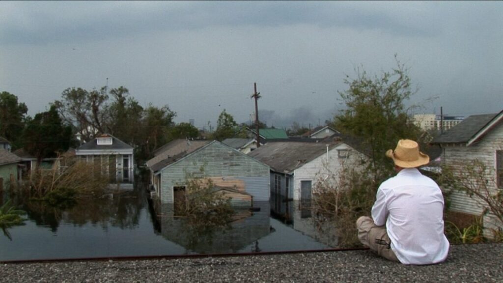
A man is stranded on a rooftop in the aftermath of Hurricane Katrina in 2005. Credit: Wickes Helmboldt
Next month marks the 20th anniversary of one of the most devastating natural disasters in US history: Hurricane Katrina, a Category 3 storm that made landfall on August 29, 2005. The storm itself was bad enough, but the resulting surge of water caused havoc for New Orleans in particular when the city’s protective levees failed, flooding much of New Orleans and killing 1,392 people. National Geographic is marking the occasion with a new documentary series: Hurricane Katrina: Race Against Time.
The five-part documentary is directed by Oscar nominee Traci A. Curry (Attica) and co-produced by Ryan Coogler’s Proximity Media, in conjunction with Lightbox. The intent was to go beyond the headlines of yesteryear and re-examine the many systemic failures that occurred while also revealing “stories of survival, heroism, and resilience,” Proximity’s executive producers said in a statement. “It’s a vital historical record and a call to witness, remember and recon with the truth of Hurricane Katrina’s legacy.”
Race Against Time doesn’t just rehash the well-worn narrative of the disaster; it centers the voices of the people who were there on the ground: residents, first responders, officials, and so forth. Among those interviewed for the documentary is geologist/marine scientist Ivor Van Heerden, author of The Storm: What Went Wrong and Why During Hurricane Katrina: the Inside Story from One Louisiana Scientist (2006).
Around 1998, Van Heerden set up Louisiana State University’s (LSU) fledgling Hurricane Center with his colleague Marc Levitan, developing the first computer modeling efforts for local storm surges. They had a supercomputer for the modeling and LiDAR data for accurate digital elevation models, and since there was no way to share data among the five major parishes, they created a networked geographical information system GIS) to link them. Part of Van Heerden’s job involved driving all over New Orleans to inspect the levees, and he didn’t like what he saw: levees with big bows, sinking under their own weight, for example, and others with large cracks.
Van Heerden also participated in the 2004 Hurricane Pam mock scenario, designed as a test run for hurricane planning for the 13 parishes of southeastern Louisiana, including New Orleans. It was essentially a worst-case scenario for the conditions of Hurricane Betsy, assuming that the whole city would be flooded. “We really had hoped that the exercise would wake everybody up, but quite honesty we were laughed at a few times during the exercise,” Van Heerden told Ars. He recalled telling one woman from FEMA that they should be thinking about using tents to house evacuees: “She said, ‘Americans don’t live in tents.'”
Stormy weather
Mayor Ray Nagin orders a mandatory evacuation of New Orleans. ABC News Videosource
The tens of thousands of stranded New Orleans residents in the devastating aftermath of Katrina could have used those tents. Van Heerden still vividly recalls his frustration over the catastrophic failures that occurred on so many levels. “We knew the levees had failed, we knew that there had been catastrophic structural failure, but nobody wanted to hear it initially,” he said. He and his team were out in the field in the immediate aftermath, measuring water levels and sampling the water for pathogens and toxic chemicals. Naturally they came across people in need of rescue and were able to radio locations to the Louisiana State University police.
“An FBI agent told me, ‘If you find any bodies, tie them with a piece of string to something so they don’t float away and give us the lats and logs,'” Van Heerden recalled. The memories haunt him still. Some of the bodies were drowned children, which he found particularly devastating since he had a young daughter of his own at the time.
How did it all go so wrong? After 1965’s Hurricane Betsy flooded most of New Orleans, the federal government started a levee building program with the US Army Corps of Engineers (USACE) in charge. “Right at the beginning, the Corps used very old science in terms of determining how high to make the levees,” said Van Heerden. “They had access to other very good data, but they chose not to use it for some reason. So they made the levees way too low.”
“They also ignored some of their own geotechnical science when designing the levees,” he continued. “Some were built in sand with very shallow footings, so the water just went underneath and blew out the levee. Some were built on piles of earth, again with very shallow footings, and they just fell over. The 17th Street Canal, the whole levee structure actually slid 200 feet.”
There had also been significant alterations to the local landscape since Hurricane Betsy. In the past, the wetlands, especially the cypress tree swamps, provided some protection from storm surges. In 1992, for example, the Category 5 Hurricane Andrew made landfall on Atchafalaya Delta, where healthy wetlands reduced its energy by 50 percent between the coast and Morgan City, per Van Heerden. But other wetlands in the region changed drastically with the dredging of a canal called the Mississippi Gulf Outlet, running from Baton Rouge to the Gulf of Mexico.
“It was an open conduit for surge to get into New Orleans,” said Van Heerden. “The saltwater got into the wetlands and destroyed it, especially the cypress trees. This canal had opened up, in some places, to five times its width, allowing waves to build on the surface. The earthen levees weren’t armored in any way, so they just collapsed. They blew apart. That’s why parts of St. Bernard saw a wave of water 10 feet high.”
Just trying to survive
Stranded New Orleans residents gather in a shelter during Hurricane Katrina. KTVT-TV
Add in drastic cuts to FEMA under then-President George W. Bush—who inherited “a very functional, very well-organized” version of the department from his predecessor, Bill Clinton, per Van Heerden—and the stage was set for just such a disaster like Katrina’s harrowing aftermath. It didn’t help that New Orleans Mayor Ray Nagin delayed issuing a mandatory evacuation order until some 24 hours before the storm hit, making it much more difficult for residents to follow those orders in a timely fashion.
There were also delays in conveying the vital information that the levees had failed. “We now know that the USACE had a guy in a Coast Guard helicopter who actually witnessed the London Avenue Canal failure, at 9: 06 AM on Day One,” said Van Heerden. “That guy went to Baton Rouge and he didn’t tell a soul other than the Corps. So the Corps knew very early what was gong on and they did nothing about it. They had a big megaphone and millions of dollars in public relations and kept saying it was an act of God. It took until the third week of September for us to finally get the media to realize that this was a catastrophic failure of the levees.”
The USACE has never officially apologized for what happened, per Van Heerden. “Not one of them lost their job after Katrina,” he said. But LSU fired Van Heerden in 2009, sparking protest from faculty and students. The university gave no reason for his termination, but it was widely speculated at the time that Van Heerden’s outspoken criticism of the USACE was a factor, with LSU fearing it might jeopardize funding. Van Heerden, sued and the university settled. But he hasn’t worked in academia since and now consults with various nonprofit organizations on flooding and storm surge impacts.
The widespread reports of looting and civil war further exacerbated the situation as survivors swarmed the Superdome and the nearby convention center. The city had planned for food and water for 12,000 people housed at Superdome for 48 hours. The failure of the levees swelled that number to 30,000 people stranded for several days, waiting in vain for the promised cavalry to arrive.
Van Heerden acknowledges the looting but insists most of that was simply due to people trying to survive in the absence of any other aid. “How did they get water on the interstate?” said Van Heerden. “They went to a water company, broke in and hot-wired a truck, then went around and gave water to everyone.”
As for the widespread belief outside the city that there was unchecked violence and a brewing civil war, “That doesn’t happen in a catastrophe,” he said. The rumors were driven by reports of shots being fired but, “there are a lot of hunters in Louisiana, and the hunter’s SOS is to fire three shots in rapid succession,” he said. “One way to say ‘I’m here!’ is to fire a gun. But everybody bought into that civil war nonsense.”
“Another ticking time bomb”
LSU Hurricane Center co-founder Ivor Van Heerden working at his desk in 2005. Australian Broadcasting Corporation
The levees have since been rebuilt, and Van Heerden acknowledges that some of the repairs are robust. “They used more concrete, they put in protection pads and deeper footings,” he said. “But they didn’t take into account—and they admitted this a few years ago—subsidence in Louisiana, which is two to two-and-a-half feet every century. And they didn’t take into account global climate change and the associated rising sea levels. Within the next 70 years, sea level in Louisiana is going to rise four feet over millions of square miles. If you’ve got a levee with a [protective] marsh in front of it, before too long that marsh is no longer going to exist, so the water is going to move further and further in-shore.”
Then there’s the fact that hurricanes these days are now bigger in diameter than they were 30 years ago, thanks to the extra heat. “They get up to a Category 5 a lot quicker,” said Van Heerden. “The frequency also seems to be creeping up. It’s now four times as likely you will experience hurricane-force winds.” Van Heerden has run storm surge models assuming a 3-foot rise in sea level. “What we saw was the levees wouldn’t be high enough in New Orleans,” he said. “I hate to say it, but it looks like another ticking time bomb. Science is a quest for the truth. You ignore the science at your folly.”
Assuming there was sufficient public and political will, how should the US be preparing for future tropical storms? “In many areas we need to retreat,” said Van Heerden. “We need to get the houses and buildings out and rebuild the natural vegetation, rebuild the wetlands. On the Gulf Coast, sea level is really going to rise, and we need to rethink our infrastructure. This belief that, ‘Oh, we’re going to put up a big wall’—in the long run it’s not going to work. The devastation from tropical storms is going to spread further inland through very rapid downpours, and that’s something we’re going to have to plan mitigations for. But I just don’t see any movement in that direction.”
Perhaps documentaries like Race Against Time can help turn the tide; Van Heerden certainly hopes so. He also hopes the documentary can correct several public misconceptions of what happened—particularly the tendency to blame the New Orleans residents trying to survive in appalling conditions, rather than the government that failed them.
“I think this is a very good documentary in showing the plight of the people and what they suffered, which was absolutely horrendous,” said Van Heerden. “I hope people watching will realize that yes, this is a piece of our history, but sometimes the past is the key to the present. And ask themselves, ‘Is this a foretaste of what’s to come?'”
Hurricane Katrina: Race Against Time premieres on July 27, 2025, on National Geographic. It will be available for streaming starting July 28, 2025, on Disney+ and Hulu.

Jennifer is a senior writer at Ars Technica with a particular focus on where science meets culture, covering everything from physics and related interdisciplinary topics to her favorite films and TV series. Jennifer lives in Baltimore with her spouse, physicist Sean M. Carroll, and their two cats, Ariel and Caliban.
20 years after Katrina, New Orleans remembers Read More »