The remaining question, though, was where all this methane was coming from in the first place. Throughout the pandemic, there was speculation that the surge might be caused by super-emitter events in the oil and gas sector, or perhaps a lack of maintenance on leaky infrastructure during lockdowns.
But the new research suggests that the source of these emissions was not what many expected.
The microbial surge
While the weakened atmospheric sink explained the bulk of the 2020 surge, it wasn’t the only factor at play. The remaining 20 percent of the growth, and an even larger portion of the growth in 2021 and 2022, came from an increase in actual emissions from the ground. To track the source of these emissions down, Peng’s team went through tons of data from satellites and various ground monitoring stations.
Methane comes in different isotopic signatures. Methane from fossil fuels like natural gas leaks or coal mines is heavier, containing a higher fraction of the stable isotope carbon-13. Conversely, methane produced by microbes found in the guts of livestock, in landfills, and most notably in wetlands, is lighter, enriched in carbon-12.
When the researchers analyzed data from the National Oceanic and Atmospheric Administration global flask network, a worldwide monitoring system tracking the chemical composition of Earth’s atmosphere, they found that the atmospheric methane during the mysterious surge was becoming significantly lighter. This was a smoking gun for biogenic sources. The surge wasn’t coming from pipes or power plants; it was coming from microbes.
La Niña came to play
The timing of the pandemic coincided with a relatively rare meteorological event. La Niña, the cool phase of the El Niño–Southern Oscillation that typically leads to increased rainfall in the tropics, lasted for three consecutive Northern Hemisphere winters (from 2020 to 2023). This made the early 2020s exceptionally wet.
The researchers used satellite data from the Greenhouse Gases Observing Satellite and sophisticated atmospheric models to trace the source of the light methane to vast wetland areas in tropical Africa and Southeast Asia. In regions like the Sudd in South Sudan and the Congo Basin, record-breaking rainfall flooded massive swaths of land. In these waterlogged, oxygen-poor environments, microbial methanogens thrived, churning out methane at an accelerated pace.
Starship’s next chapter will involve launching over Florida and returning over Mexico.
SpaceX’s Starship vehicle is encased in plasma as it reenters the atmosphere over the Indian Ocean on its most recent test flight in August. Credit: SpaceX
Some time soon, perhaps next year, SpaceX will attempt to fly one of its enormous Starship rockets from low-Earth orbit back to its launch pad in South Texas. A successful return and catch at the launch tower would demonstrate a key capability underpinning Elon Musk’s hopes for a fully reusable rocket.
In order for this to happen, SpaceX must overcome the tyranny of geography. Unlike launches over the open ocean from Cape Canaveral, Florida, rockets departing from South Texas must follow a narrow corridor to steer clear of downrange land masses.
All 10 of the rocket’s test flights so far have launched from Texas toward splashdowns in the Indian or Pacific Oceans. On these trajectories, the rocket never completes a full orbit around the Earth, but instead flies an arcing path through space before gravity pulls it back into the atmosphere.
If Starship’s next two test flights go well, SpaceX will likely attempt to send the soon-to-debut third-generation version of the rocket all the way to low-Earth orbit. The Starship V3 vehicle will measure 171 feet (52.1 meters) tall, a few feet more than Starship’s current configuration. The entire rocket, including its Super Heavy booster, will have a height of 408 feet (124.4 meters).
Starship, made of stainless steel, is designed for full reusability. SpaceX has already recovered and reflown Super Heavy boosters, but won’t be ready to recover the rocket’s Starship upper stage until next year, at the soonest.
That’s one of the next major milestones in Starship’s development after achieving orbital flight. SpaceX will attempt to bring the ship home to be caught back at the launch site by the launch tower at Starbase, Texas, located on the southernmost section of the Texas Gulf Coast near the US-Mexico border.
It was always evident that flying a Starship from low-Earth orbit back to Starbase would require the rocket to fly over Mexico and portions of South Texas. The rocket launches to the east over the Gulf of Mexico, so it must approach Starbase from the west when it comes in for a landing.
New maps published by the Federal Aviation Administration show where the first Starships returning to Texas may fly when they streak through the atmosphere.
Paths to and from orbit
The FAA released a document Friday describing SpaceX’s request to update its government license for additional Starship launch and reentry trajectories. The document is a draft version of a “tiered environmental assessment” examining the potential for significant environmental impacts from the new launch and reentry flight paths.
The federal regulator said it is evaluating potential impacts in aviation emissions and air quality, noise and noise-compatible land use, hazardous materials, and socioeconomics. The FAA concluded the new flight paths proposed by SpaceX would have “no significant impacts” in any of these categories.
SpaceX’s Starship rocket shortly before splashing into the Indian Ocean in August. Credit: SpaceX
The environmental review is just one of several factors the FAA considers when deciding whether to approve a new commercial launch or reentry license. According to the FAA, the other factors are public safety issues (such as overflight of populated areas and payload contents), national security or foreign policy concerns, and insurance requirements.
The FAA didn’t make a statement on any public safety and foreign policy concerns with SpaceX’s new trajectories, but both issues may come into play as the company seeks approval to fly Starship over Mexican towns and cities uprange from Starbase.
The regulator’s licensing rules state that a commercial launch and reentry should each pose no greater than a 1 in 10,000 chance of harming or killing a member of the public not involved in the mission. The risk to any individual should not exceed 1 in 1 million.
So, what’s the danger? If something on Starship fails, it could disintegrate in the atmosphere. Surviving debris would rain down to the ground, as it did over the Turks and Caicos Islands after two Starship launch failures earlier this year. Two other Starship flights ran into problems once in space, tumbling out of control and breaking apart during reentry over the Indian Ocean.
The most recent Starship flight last month was more successful, with the ship reaching its target in the Indian Ocean for a pinpoint splashdown. The splashdown had an error of just 3 meters (10 feet), giving SpaceX confidence in returning future Starships to land.
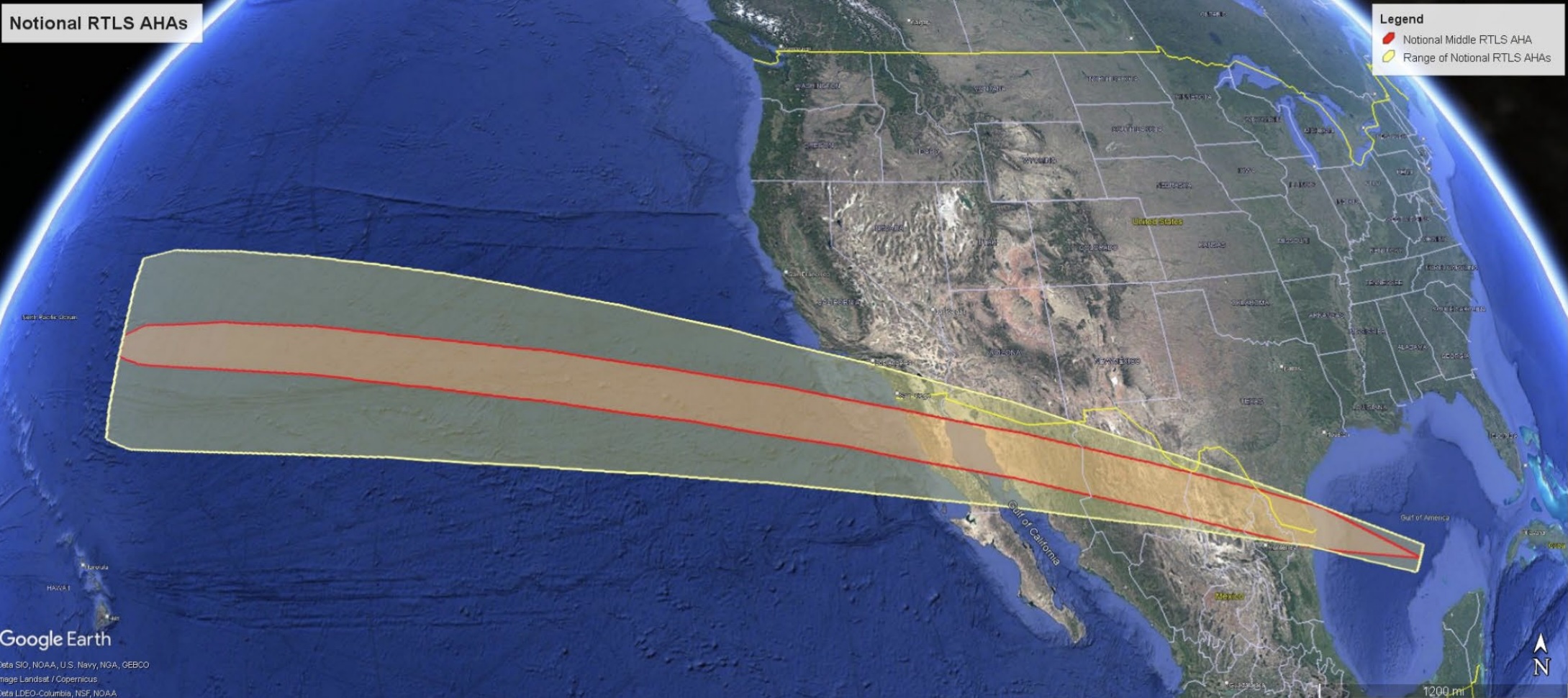
This map shows Starship’s proposed reentry corridor. Credit: Federal Aviation Administration
One way of minimizing the risk to the public is to avoid flying over large metropolitan areas, and that’s exactly what SpaceX and the FAA are proposing to do, at least for the initial attempts to bring Starship home from orbit. A map of a “notional” Starship reentry flight path shows the vehicle beginning its reentry over the Pacific Ocean, then passing over Baja California and soaring above Mexico’s interior near the cities of Hermosillo and Chihuahua, each with a population of roughly a million people.
The trajectory would bring Starship well north of the Monterrey metro area and its 5.3 million residents, then over the Rio Grande Valley near the Texas cities of McAllen and Brownsville. During the final segment of Starship’s return trajectory, the vehicle will begin a vertical descent over Starbase before a final landing burn to slow it down for the launch pad’s arms to catch it in midair.
In addition to Monterrey, the proposed flight path dodges overflights of major US cities like San Diego, Phoenix, and El Paso, Texas.
Let’s back up
Setting up for this reentry trajectory requires SpaceX to launch Starship into an orbit with exactly the right inclination, or angle to the equator. There are safety constraints for SpaceX and the FAA to consider here, too.
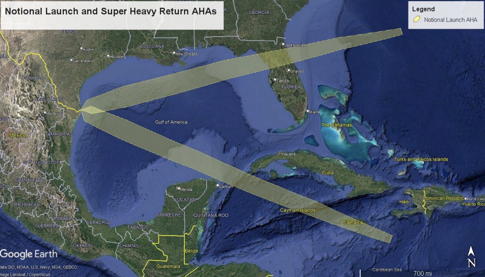
All of the Starship test flights to date have launched toward the east, threading between South Florida and Cuba, south of the Bahamas, and north of Puerto Rico before heading over the North Atlantic Ocean. For Starship to target just the right orbit to set up for reentry, the rocket must fly in a slightly different direction over the Gulf.
Another map released by the FAA shows two possible paths Starship could take. One of the options goes to the southeast between Mexico’s Yucatan Peninsula and the western tip of Cuba, then directly over Jamaica as the rocket accelerated into orbit over the Caribbean Sea. The other would see Starship departing South Texas on a northeasterly path and crossing over North Florida before reaching the Atlantic Ocean.
While both trajectories fly over land, they avoid the largest cities situated near the flight path. For example, the southerly route misses Cancun, Mexico, and the northerly path flies between Jacksonville and Orlando, Florida. “Orbital launches would primarily be to low inclinations with flight trajectories north or south of Cuba that minimize land overflight,” the FAA wrote in its draft environmental assessment.
The FAA analyzed two launch trajectory options for future orbital Starship test flights. Credit: Federal Aviation Administration
The proposed launch and reentry trajectories would result in temporary airspace closures, the FAA said. This could force delays or rerouting of anywhere from seven to 400 commercial flights for each launch, according to the FAA’s assessment.
Launch airspace closures are already the norm for Starship test flights. The FAA concluded that the reentry path over Mexico would require the closure of a swath of airspace covering more than 4,200 miles. This would affect up to 200 more commercial airplane flights during each Starship mission. Eventually, the FAA aims to shrink the airspace closures as SpaceX demonstrates improved reliability with Starship test flights.
Eventually, SpaceX will move some flights of Starship to Florida’s Space Coast, where rockets can safely launch in many directions over the Atlantic. By then, SpaceX aims to be launching Starships at a regular cadence—first, multiple flights per month, then per week, and then per day.
This will enable all of the things SpaceX wants to do with Starship. Chief among these goals is to fly Starships to Mars. Before then, SpaceX must master orbital refueling. NASA also has a contract with SpaceX to build Starships to land astronauts on the Moon’s south pole.
But all of that assumes SpaceX can routinely launch and recover Starships. That’s what engineers hope to soon prove they can do.
Stephen Clark is a space reporter at Ars Technica, covering private space companies and the world’s space agencies. Stephen writes about the nexus of technology, science, policy, and business on and off the planet.
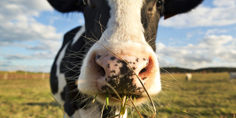
In the urgent quest for a more sustainable global food system, livestock are a mixed blessing. On the one hand, by converting fibrous plants that people can’t eat into protein-rich meat and milk, grazing animals like cows and sheep are an important source of human food. And for many of the world’s poorest, raising a cow or two—or a few sheep or goats—can be a key source of wealth.
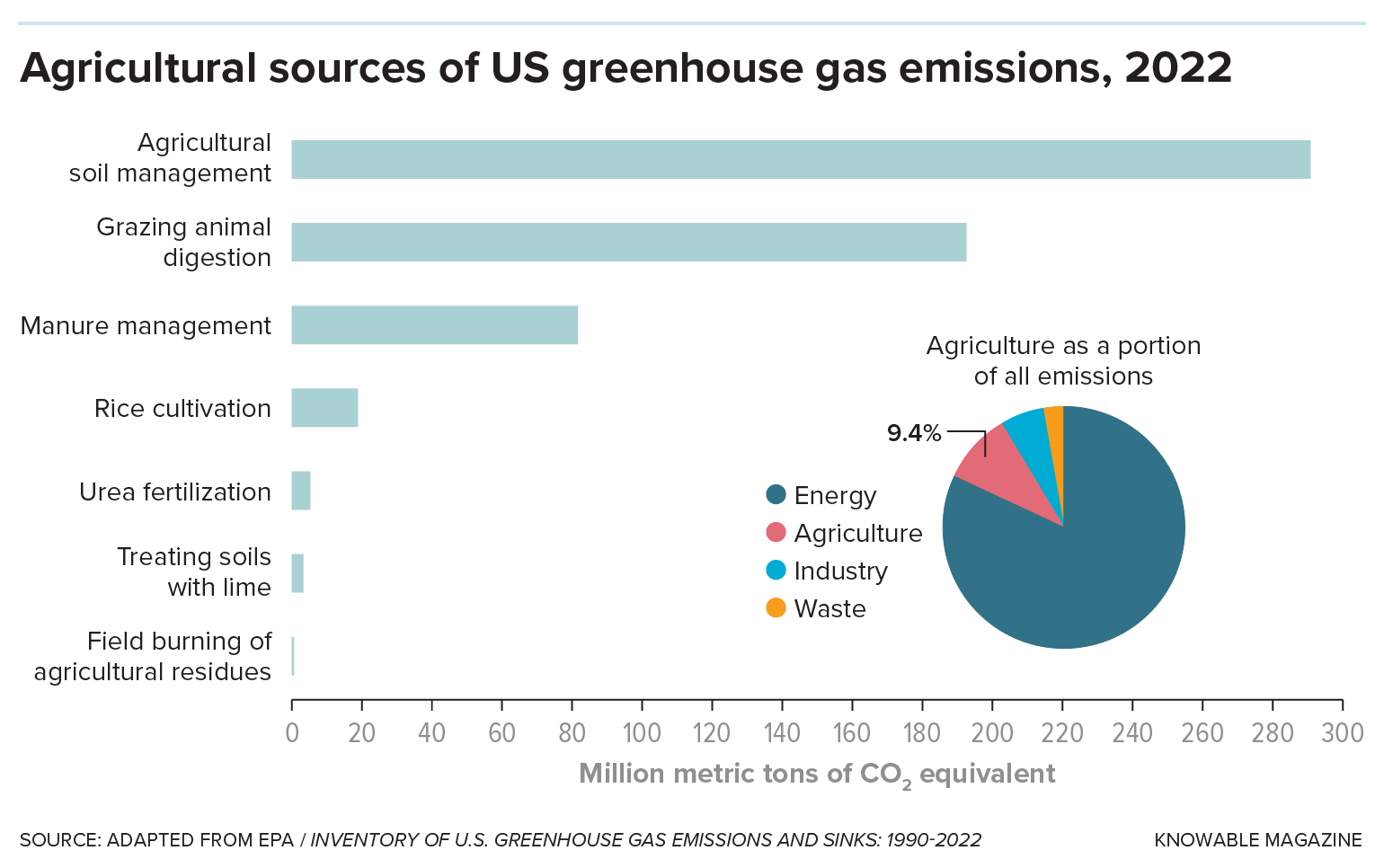
But those benefits come with an immense environmental cost. A study in 2013 showed that globally, livestock account for about 14.5 percent of greenhouse gas emissions, more than all the world’s cars and trucks combined. And about 40 percent of livestock’s global warming potential comes in the form of methane, a potent greenhouse gas formed as they digest their fibrous diet.
That dilemma is driving an intense research effort to reduce methane emissions from grazers. Existing approaches, including improved animal husbandry practices and recently developed feed additives, can help, but not at the scale needed to make a significant global impact. So scientists are investigating other potential solutions, such as breeding low-methane livestock and tinkering with the microbes that produce the methane in grazing animals’ stomachs. While much more research is needed before those approaches come to fruition, they could be relatively easy to implement widely and could eventually have a considerable impact.
Knowable Magazine
The good news—and an important reason to prioritize the effort—is that methane is a relatively short-lived greenhouse gas. Whereas the carbon dioxide emitted today will linger in the atmosphere for more than a century, today’s methane will wash out in little more than a decade. So tackling methane emissions now can lower greenhouse gas levels and thus help slow climate change almost immediately.
“Reducing methane in the next 20 years is about the only thing we have to keep global warming in check,” says Claudia Arndt, a dairy nutritionist working on methane emissions at the International Livestock Research Institute in Nairobi, Kenya.
The methane dilemma
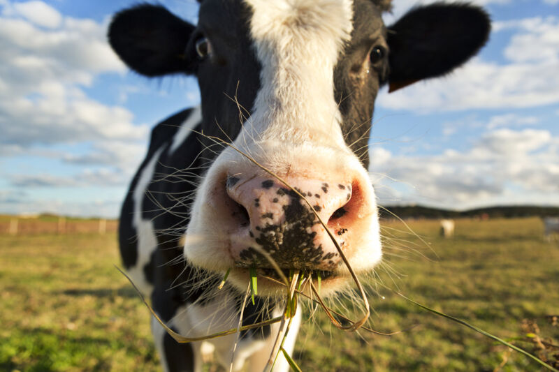
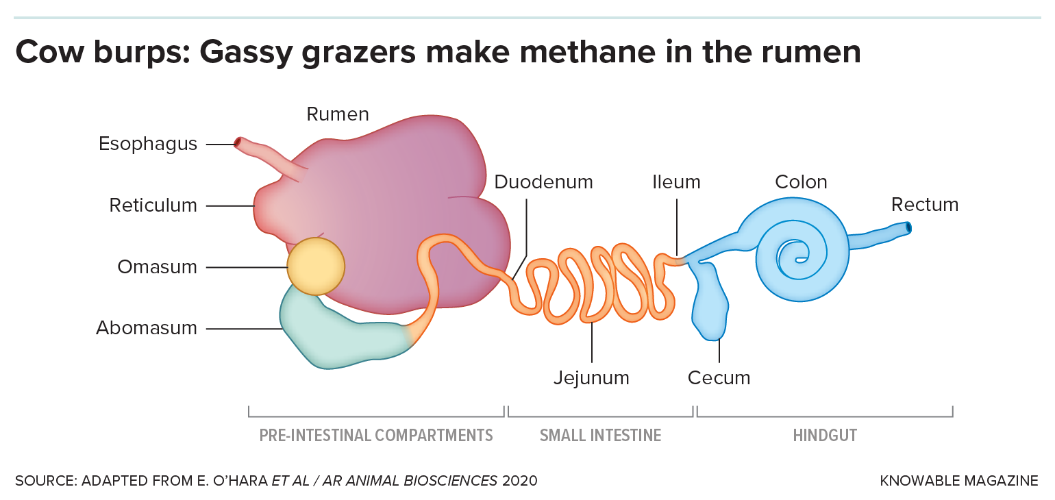
The big challenge in lowering methane is that the gas is a natural byproduct of what makes grazing animals uniquely valuable: their partnership with a host of microbes. These microbes live within the rumen, the largest of the animals’ four stomachs, where they break down the fibrous food into smaller molecules that the animals can absorb for nutrition. In the process, they generate large amounts of hydrogen gas, which is converted into methane by another group of microbes called methanogens.
Enlarge/ The microbes that digest fiber—and those that produce methane—live mostly in the rumen, the first and largest of a cow’s four stomachs.
Knowable Magazine
Most of this methane, often referred to as enteric methane, is belched or exhaled out by the animals into the atmosphere—just one cow belches out around 220 pounds of methane gas per year, for example. (Contrary to popular belief, very little methane is expelled in the form of farts. Piles of manure that accumulate in feedlots and dairy barns account for about a quarter of US livestock methane, but aerating the piles or capturing the methane for biogas can prevent those emissions; the isolated cow plops from pastured grazing animals generate little methane.)
When discussing climate change, attention generally focuses on our soaring carbon dioxide emissions. But levels of methane have risen just as dramatically, and it’s a far more potent greenhouse gas. And, unlike carbon dioxide, it’s not the end result of a valuable process; methane largely ends up in the atmosphere as the result of waste, lost during extraction and distribution.
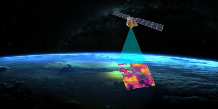
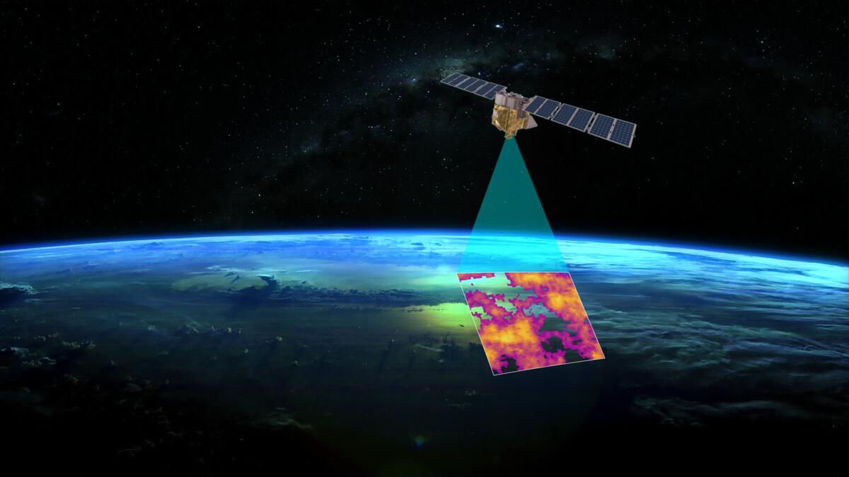
Getting these losses under control would be one of the easiest ways to slow down greenhouse warming. But tracking methane emissions often comes from lots of smaller, individual sources. To help get a handle on all the leaks, the Environmental Defense Fund has been working to put its own methane-monitoring satellite in orbit. On Wednesday, it announced that it was partnering with Google to take the data from the satellite, make it publicly available, and tie it to specific sources.
The case for MethaneSAT
Over the course of 20 years, methane is 84 times more potent than carbon dioxide when it comes to greenhouse warming. And most methane in the atmosphere ultimately reacts with oxygen, producing water vapor and carbon dioxide—both of which are also greenhouse gasses. Those numbers are offset by the fact that methane levels in the atmosphere are very low, currently just under two parts per million (versus over 400 ppm for CO2). Still, levels have gone up considerably since monitoring started.
The primary source of the excess methane is the extraction and distribution of natural gas. In the US, the EPA has developed rules meant to force companies with natural gas infrastructure to find and fix leaks. (Unsurprisingly, Texas plans to sue to block this rule.) But finding leaks has turned out to be a challenge. The US has been using industry-wide estimates that turned out to be much lower than numbers based on monitoring a subset of facilities.
Globally, that sort of detailed surveying simply isn’t possible, and we don’t have the type of satellite-based instruments we need to focus on methane emissions. A researcher behind one global survey said, “We were quite disappointed because we discovered that the sensitivity of our system was pretty low.” (The survey did identify sites that were “ultra emitters” despite the sensitivity issues.)
To help identify the major sources of methane release, the Environmental Defense Fund, a US-based NGO, has spun off a project called MethaneSAT that will monitor the emissions from space. The project is backed by large philanthropic donations and has partnered with the New Zealand Space Agency. The Rocket Lab launch company will build the satellite control center in New Zealand, while SpaceX will carry the 350 kg satellite to orbit in a shared launch, expected in early March.
Once in orbit, the hardware will use methane’s ability to absorb in the infrared—the same property that causes all the problems—to track emissions globally at a resolution down below a square kilometer.
Handling the data
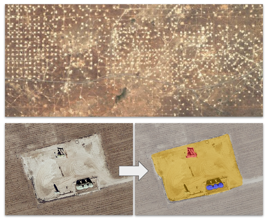
That will generate large volumes of data that countries may struggle to interpret. That’s where the new Google partnership will come in. Google will use the same AI capability it has developed to map features such as roads and sidewalks on satellite images but repurpose it to identify oil and gas infrastructure. Both the MethaneSAT’s emissions data and infrastructure details will be combined and made available via the company’s Google Earth service.
Top image: A view of an area undergoing oil/gas extraction. Left: a close-up of an individual drilling site. Right: Computer-generated color coding of the hardware present at the site.
Google / EDF
The project builds off work Google has done previously by placing methane monitoring hardware on Street View photography vehicles, also in collaboration with the Environmental Defense Fund.
In a press briefing, Google’s Yael Maguire said that the challenge is keeping things up to date, as infrastructure in the oil and gas industry can change fairly rapidly. While he didn’t use it as an example, one illustration of that challenge was the rapid development of liquified natural gas import infrastructure in Europe in the wake of Russia’s invasion of Ukraine.
The key question, however, is one of who’s going to use this information. Extraction companies could use it to identify the sites of leaks and fix them but are unlikely to do that in the absence of a regulatory requirement. Governments could rely on this information to take regulatory actions but will probably want some sort of independent vetting of the data before doing so. At the moment, all EDF is saying is that it’s engaging in discussions with several parties about potentially using the data.
One clear user will be the academic community, which is already using less-targeted satellite data to explore the issue of methane emissions.
Regardless, as everyone involved in the project emphasizes, getting methane under control is probably the easiest and quickest way to eliminate a bit of impending warming. And that could help countries meet emissions targets without immediately starting on some of the slower and more expensive options. So, even if no one has currently committed to using this data, they may ultimately come around—because using it to do something is better than doing nothing.


